ISOM tells you which of its own rules are absolute
A mapper's real question is not how to draw something. It is whether the standard obliges them. ISOM answers that in a vocabulary it defines before the symbols begin, and the answer changes from symbol to symbol.
 Andrey Surzhikov
Open ISOM 2017-2 at section 1.1, before the symbols, before the general requirements. Six lines, about a hundred and fifty words. They define what the rest of the document means when it says must, should and may.
Must / Shall / Required mean that the definition is an absolute requirement. Should / Recommended mean that there may exist valid reasons in particular circumstances to ignore a particular item, but the full implications must be understood and carefully weighed before choosing a different course. May / Optional mean that an item is truly optional.
This is the answer to the question every mapper actually has. Not how do I draw a boulder, but does this oblige me. And the standard sorts its own sentences for you, one word at a time.
The standard says which of its own rules are absolute, and it says it in six lines at the front that almost nobody reads
How much of ISOM is binding
Counting the words in the current edition gives a rough shape of the document: 71 occurrences of must, 64 of shall, 68 of should, 64 of may. Twenty eight shall not and three must not mark the outright prohibitions.
Binding and advisory come out roughly even. More usefully, they are not separated into sections. They are mixed inside the description of a single symbol, sometimes inside a single sentence, and the only thing telling them apart is the verb.
Three symbols on the same page, three different obligations
Section 3.2 describes rock features. A cliff, symbol 202, carries a bare statement: minimum height 1 m. None of the verbs from 1.1 appears next to it, so the number is simply the definition.
A boulder, symbol 204, is described differently. It should be higher than 1 m. Same page, same family of features, and now the number is a recommendation you may set aside if you understand what you are setting aside.
An impassable cliff, symbol 201, has no height threshold at all. It is defined by what it does to a runner: so high and steep that it is impossible to pass or climb, or dangerous. The judgement is handed to the mapper on purpose, because no number survives contact with real rock.
Three neighbouring symbols, three different kinds of instruction. A mapper who reads all three as equally binding will fight the standard where it was trying to get out of the way.
Two words that do not mean what they look like
Impassable and uncrossable describe terrain, not permission. The standard spells this out:
a feature is too difficult or dangerous to go through or over by the average elite orienteer under normal conditions. It is not forbidden, but it may pose a risk to the competitor.
That final sentence was added in January 2024. Before that the standard was silent, and the silence was filled by everyone’s assumption that a thick black line meant a wall you were banned from crossing. Whether crossing is allowed is a question for the competition rules, which are a different document with a different author. The map only reports what is there.
“Impassable” describes the terrain, not a rule. The standard says outright that it is not forbidden
One more thing about that vocabulary: your national edition may not have it. Federations publish their own translations of ISOM, and they are not always the same document. The official Finnish edition is an abridgement whose first chapter carries no such vocabulary at all. The Swiss French edition of the current revision defines the same word but leaves out the sentence saying it is not forbidden, and points instead at a national rule that forbids crossing. Everything quoted here is the IOF original, in English, and where your own edition differs, the difference is worth knowing about before you rely on it.
Where the colour order lives
Section 2.12 of ISOM is one sentence long. It says that the document IOF Map Specifications, Printing and Colour Definitions applies, and stops.
So the colour order is not in the map standard at all. It sits in a separate specification, revised on its own schedule, and it is the part that decides what covers what when two features meet. A mapper who reads ISOM cover to cover and never opens the second document has read everything about which symbols exist and nothing about how they stack.
The colour order is not in ISOM at all, and it is the part that decides what covers what
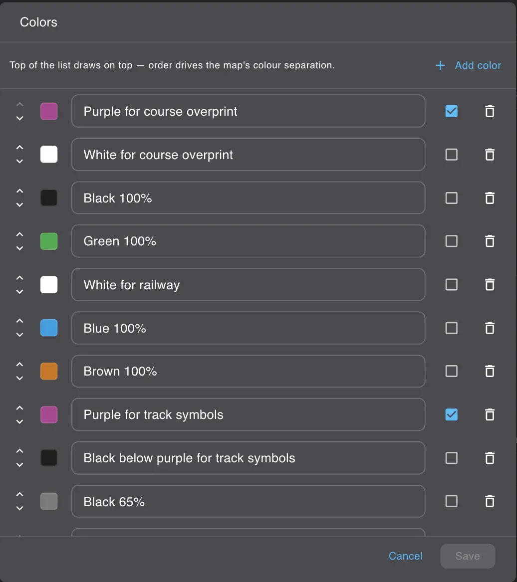
A colour in the table is not a colour
The ISOM set in Gratic carries 35 colour entries. Count the distinct CMYK recipes among them and you get 19.
Five entries are the same black: 0, 0, 0, 100. They are named Black 100%, Black below purple for track symbols, Black below upper brown 50%, Black below lower brown 50% and Black for open land. Four entries are the same nothing: 0, 0, 0, 0. Their names all begin with White, and on paper white means the ink is knocked out and the page shows through.
Black below upper brown 50% is not a darker black or a special black. It is ordinary black that has to sink. The name is an instruction about depth, and depth is the whole content of the entry.
A colour in the table is not a colour but a depth: thirty-five entries, nineteen inks
The reason is how a map is printed. Not one object at a time, but one colour at a time, from the bottom of the stack upwards. A road’s black casing lies under every brown on the map: under its own carriageway, under the next road’s, under the fill of a paved area it crosses. Draw the casing together with its own line instead, and black climbs over brown wherever two roads meet.
Put the four road entries in order and the machine becomes visible. Brown for the carriageway, black beneath it for the line that separates two carriageways, brown again for the paved area, black beneath that for the road’s casing. Junctions resolve themselves, because each part was told which floor it lives on.
Nobody checks any of this
Here is the part that surprises people who assume a map editor enforces the standard.
Every number ISOM fixes appears in Gratic as an ordinary input field. The width of a contour is a box containing 0.14. Type 0.9 into it and the contour becomes nine tenths of a millimetre thick on paper, and nothing objects. The dash length of a footpath, the spacing of marsh hatching, the CMYK of any ink, the order of the entries: all editable, none guarded.
This is not our omission. OCAD has a legibility check that measures gaps, line lengths and areas against ISOM, and its own documentation notes that it does not check minimum widths; symbol definitions and colour order it does not check at all. OpenOrienteering Mapper generates a report for you to read with your own eyes, and warns in its manual that any symbol you modify is a departure from the standard. Neither program will stop you, and neither knows which edition of the standard your file was drawn to.
Every number the standard fixes is an ordinary input field, in Gratic and in every other editor
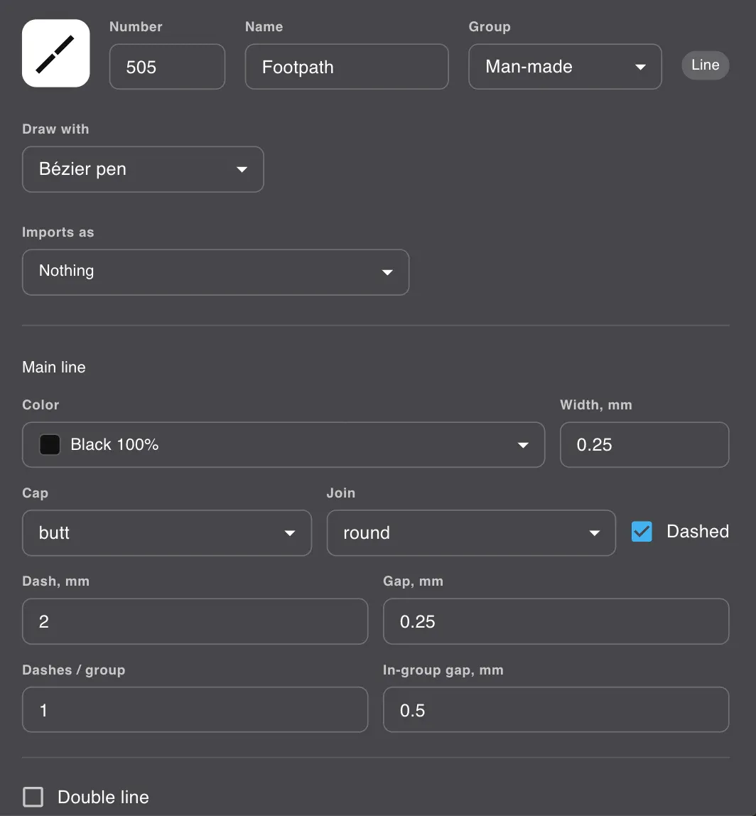
So the standard is kept by a person, not by a program. That is worth knowing before you start, because it changes what you are looking for when you check your own work: not a green tick, but a habit of asking which verb the standard used.
If you want to see the numbers rather than read about them, the whole set is in front of you: open a map in Gratic, pick any symbol, and the widths, dashes and colour order are the same fields this article has been describing.
What to do with this
Read section 1.1 first, once, and keep it in mind while you read anything else. When a symbol description gives you a number, look at the verb next to it. If there is no verb, the number is the definition. If the verb is should, the standard has already decided that circumstances exist where you know better, and it asks only that you understand what you are trading away.
That distinction is not a loophole. It is where the standard stops writing your map for you and leaves the judgement where it belongs.
One thing worth knowing about timing: ISOM is currently frozen. The International Orienteering Federation is preparing a full revision aimed at 2030, with colour and legibility as the stated focus, and national federations have already filed what they think is broken. The document you are reading today is the one that counts, and it has been mandatory since January 2025.